It's our third and last full day here in the paradise called Boracay Island. So far, I have revisited several places that I've been to several years ago.
Today, I'm planning to check out what's beyond Station 1. However, before that, I'd join my family first for an early morning dip in the crystal clear waters near Willy's Rock.However, my wife and daughter wanted to try out the Tala dance craze first, of course, being the ever-supportive husband and dad, I volunteered my services to record a video of them doing this dance craze.
Breakfast at Diamond Water Edge Resort
More swimming time for Ella
Ella and her Korean friend
Like yesterday, we then took a dip for an hour or two before heading back to Diamond Water Edge Resort to freshen up and then eat out a complimentary breakfast. After the hearty meal, I invited my wife to join my stroll from the resort to beyond Station 1 to an area referred to in Google Maps as Diniwid Beach. My wife politely declined as wished to rest before packing up our things later. My father-in-law and daughter also preferred to stay behind to swim on the beach in front of the resort.
Checking out White Beachon my way to Diniwid Beach
From the Diamond Water Edge Resort, it took me around 15 minutes to reach the man-made pathway at the northwestern end of Station 1. I then followed the path until I reached the tip of Lambros Point. The path then became a little bit narrower thankfully there is a guide rope until the far side of the pathway.
From this part, I was first greeted by large rocks protruding off the beach sands. In just a few meters away, the beach turned out to look like an extension of Boracay Island's famed White Beach so I didn't miss out on the opportunity to take photos and relax under the shade of one of the trees near the beach. Diniwid Beach also has powdery white sand and crystal clear waters. What I like about Diniwid Beach was that it has far lesser people than White Beach.
Heading back to Diamond Water Edge Resort
Time flew so quickly when I was in Diniwid Beach that I was shocked to discover that it's already past 12NN so I rushed back to the hotel to find everyone sleeping. We skipped lunch since we were still stuffed from the heavy breakfast early today.
Time to go food tripping at d*mall
Single Coconut Ice Cream with coconut shell (P120) from Coco Mama
Korean fish cake (P100)
We left our room at around 4PM and then headed to d*mall to buy souvenirs and also scout for a place to eat dinner later. While in d*mall, we tried the Single Coconut Ice Cream with coconut shell (P120) and the Korean fish cake (P100). We also got to buy several souvenirs for our family back home.
I 💓 Backyard BBQ - Boracay Island
Team Nicerio tries out I 💓 Backyard BBQ
Ultimate Pork Belly
Pepper Steak
Fish Belly Steak
Calamari
That night, we had dinner at I 💓 Backyard BBQ. We tried pepper steak, fish belly steak, ultimate pork belly, and calamari. After dinner, we had our last night's stroll at Station 1 and 2 of White Beach before heading back to our room in Diamond Water Edge Resort to pack our bags and finalize our luggage for our flight back home tomorrow.
Late night visit to the pool.
Well, that wraps up our third and last full day here in Boracay. See you in my last Boracay Revisited 2020 article!
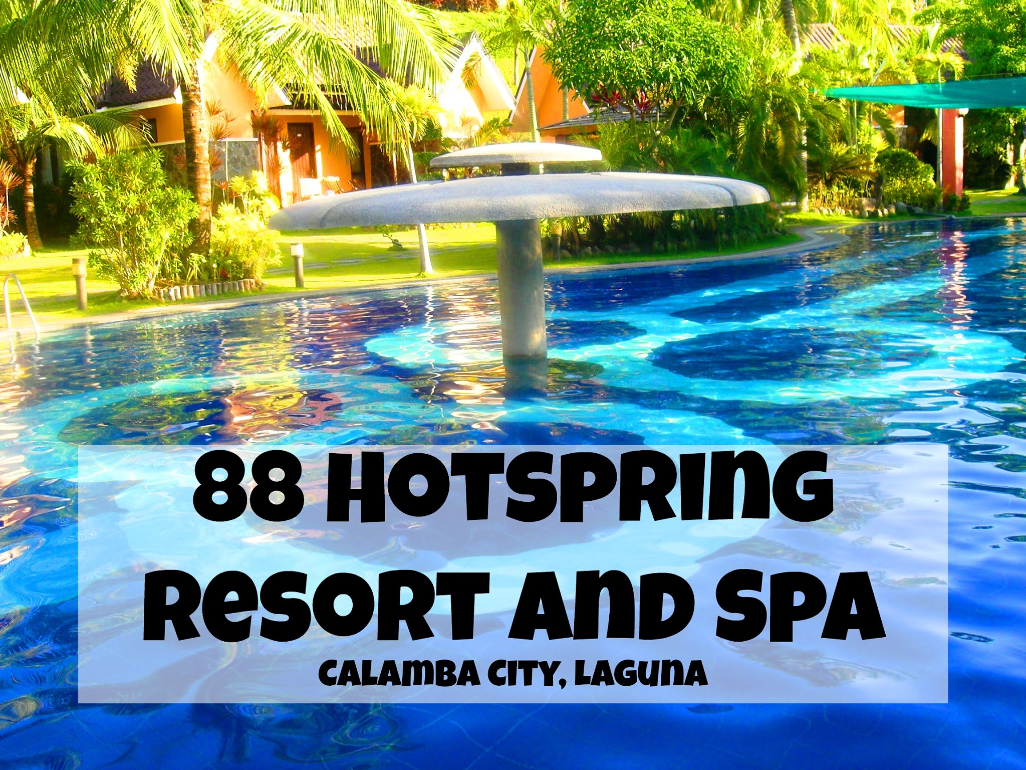
Updated: October 30, 2020 Our adventure today will take us 46.11 kilometers south from kilometer 0 in Manila. The historic atmosphere still lingers due to the historical landmarks that you can see all around this place. One of the most famous landmarks this city has to offer is the Rizal Shine or more popularly known as Rizal's house. However I'm not here to give you a history adventure but instead, I will tell you the different side of this city. 88 Hotspring Resort and Spa Calamba City in the province of Laguna is a city that has more resorts than the number of days in a year. Because of the fast-growing number of resorts (661 and counting), this city earned the nickname Resort Capital of the Philippines. 88 Hotspring Resort and Spa - Calamba, Laguna Travelers and resort seekers who didn't read my blog The Adventurer's List would surely be unprepared for what's to come. It would surely take a day for you to choose and pick the most suitable reso...
Located in the vicinity of Mt. Nagpatong in Maragondon in the province of Cavite, Andres Bonifacio Shrine and Eco-tourism Park mark the supposed place where Andres Bonifacio and his brothers Procopio were executed in 1897. Andres Bonifacio Shrine and Eco-tourism Park Andres Bonifacio Shrine and Eco-tourism Park History We learned from the previous post about Bonifacio Trial House the story of the trail leading up to the last days of Andres Bonifacio . Since I did not fully elaborate on his death, I think it is very relevant to talk about it now in relation to our featured destination - The Andres Bonifacio Shrine and Eco-tourism Park . Check out the images on the BAYANI Check out the images on the KKK A perfect angle to see the KKK and Bayani I'm wondering if that face is scared, shocked, or excited... The statue of Andres Bonifacio wearing a very fashionable camisa de chino Our local guide showed us the way to the peak of Mt. Nagpatong After his...
Otaru Steam Locomotive Museum ( 蒸気機関車資料館 ) is a train museum that is part of the Otaru City Museum. It is located at 1 Chome-3-6 Temiya, Otaru City in Hokkaido Prefecture, Japan . Otaru Steam Locomotive Museum Otaru Steam Locomotive Museum Details The Otaru Steam Locomotive Museum is a fascinating train museum located at 1 Chome-3-6 Temiya, Otaru City, Hokkaido, Japan . As part of the Otaru City General Museum , the Steam Locomotive Museum offers visitors a unique opportunity to explore the history of Hokkaido’s railways, steam engines, and railway technology. Otaru Steam Locomotive Museum - Otaru City, Hokkaido Prefecture A Historic Location The museum’s Main Building sits on 5.8 hectares of the former Temiya Line and Temiya Station, known as the birthplace of railways in Hokkaido. The site includes three facilities: the Railway , Science and History Museum , and the Steam Locomotive Museum , which is an expansive outdoor exhibition area showcasing historic railway vehi...
10 More Things to Do in Otaru City Otaru ( 小樽市 ) is a historic city in Hokkaido’s Shiribeshi Subprefecture, Japan . Known for its charm and rich heritage, Otaru offers countless attractions and activities. That’s why I’m back with another guide— 10 More Things to Do in Otaru City . Sumiyoshi Shrine 1. Visit Sumiyoshi Shrine ( 小樽住吉神社 ) , a serene and historically significant Shinto shrine in Otaru. It’s a peaceful spot to pause, reflect, and offer prayers, surrounded by traditional architecture and lush greenery. If you’re a collector of goshuin ( 御朱印 ) , the beautifully stamped shrine books, or omamori ( お守り ) , the protective charms, make sure to bring cash, as these are not typically payable by card. O-Spa 2. Unwind at Otaru Onsen Spa , also known as O-Spa ( 小樽温泉 オスパ ) , an ideal retreat after a day of exploring the city. For just 850 yen, you can enjoy the soothing hot springs and let the warm waters melt away your fatigue. The facility offers a full-day spa...
My family and I had the opportunity to explore Asahiyama Zoo ( 旭川市旭山動物園 ) for the first time on November 20, 2022 , marking my 384th day in Japan as an ALT under the JET Programme . It was the highlight of our day trip to Asahikawa City. We all enjoyed the numerous facilities in the zoo. Asahiyama Zoo Revisited 2023 That didn’t stop me from bringing my siblings there during our Sibling Roadtrip #3 when they visited Hokkaido last July 27, 2023 . It was the highlight of the day, and we spent the whole day exploring the vast zoo. Asahiyama Zoo - Asahikawa City, Hokkaido Prefecture A Brief History of Asahiyama Zoo Located at the northernmost part of Japan, Asahiyama Zoo was inaugurated on July 1, 1967, under the visionary leadership of then- Mayor Kōzō Igarashi . The zoo initially showcased 75 animal species, and despite challenges like dwindling attendance, it reinvented itself into a leading wildlife conservation center. Innovative exhibits introduced since the late 1990...
Roadside Station “Marine Island Okashima” ( 道の駅 マリーンアイランド岡島 ) is one of the roadside stations scattered all over Hokkaido. It is located along National Route 238 in 1978-13 Okashima, in the town of Esashi, Hokkaido Prefecture, Japan . Roadside Station “Marine Island Okashima” Roadside Station “Marine Island Okashima” Details Registered as an official roadside station on April 16, 1996, with Registration Number 28, Roadside Station "Marine Island Okajima" is a must-visit destination along National Route 238. Designed to mimic a ship sailing through the majestic Sea of Okhotsk, this roadside station is a favorite stop for travelers exploring Esashi Town and its scenic coastline. Roadside Station "Marine Island Okashima" - Esashi town, Hokkaido Prefecture Discover Esashi’s Seafood Treasures At the Esashi Town Specialty Products Direct Sales Shop , visitors can indulge in the best seafood the town has to offer. Highlights include: Hairy Crabs : Esa...
Otaru City Museum Main Building ( 小樽市総合博物館 本館 ), also called the Otaru City General Museum , is a museum with historical information & rail exhibits, including a model & several full-sized trains. It is located at 1 Chome-3-6 Temiya, Otaru City in Hokkaido Prefecture, Japan . Otaru City Museum Main Building Otaru City Museum Main Building Details The Otaru City General Museum is one of Hokkaido’s most fascinating cultural attractions, offering a unique glimpse into the history, nature, and technological development of Otaru and its surroundings. Originally established as the Otaru City Museum in June 1956, it was the fourth city museum in Hokkaido. In July 2007, the museum merged with the Otaru City Youth Science Museum at the former Otaru Transportation Memorial Hall site and was renamed the Otaru City General Museum . Otaru City Museum Main Building - Otaru City, Hokkaido Prefecture Two Distinct Facilities for Visitors The museum comprises two main facilities: th...
Otaru Shukutsu Panorama Observation Deck ( 小樽祝津パノラマ展望台 ) is a scenic spot in Otaru, offering breathtaking panoramic views of Ishikari Bay. It is located at 3-chome Shukutsu, Otaru, Hokkaido Prefecture, Japan . Otaru Shukutsu Panorama Observation Deck Otaru Shukutsu Panorama Observation Deck Details The Otaru Shukutsu Panorama Observation is one of the must-visit sightseeing spots in Otaru, Hokkaido. Located just a 15-minute walk from Otaru Aquarium, this observation deck is perfect for travelers looking to enjoy stunning views of Ishikari Bay and the Sea of Japan. Easily accessible by car with free parking, it’s a convenient stop for both day-trippers and long visits. Otaru Shukutsu Panorama Observation Deck - Otaru City, Hokkaido Prefecture Breathtaking Panoramic Views of Ishikari Bay Perched on a hill in northeastern Otaru City at about 70 meters above sea level, the observation deck offers sweeping panoramic views in every direction. Visitors can see the sparkling waters ...
Shiretoko National Park ( 知床国立公園 ) is one of the six national parks of Hokkaido. It covers most of the Shiretoko Peninsula, located at the northeastern tip of Hokkaido, Japan . Shiretoko National Park Shiretoko National Park Details Shiretoko National Park , located in eastern Hokkaido, is one of Japan’s last true frontiers—a dramatic, rugged peninsula where untouched wilderness meets rich cultural heritage. The name “ Shiretoko ” is derived from the Ainu language— sir etok , meaning “ the place where the earth protrudes.” This fitting name reflects the park’s geography, as the Shiretoko Peninsula juts boldly into the Sea of Okhotsk. Shiretoko National Park - Shiretoko Peninsula, Hokkaido Prefecture A UNESCO World Heritage Site of Natural Wonders Designated as a UNESCO World Heritage Site in 2005 , Shiretoko is globally recognized for its exceptional biodiversity. The area is home to Japan’s largest population of Ussuri brown bears, as well as other remarkable wildlife such a...
Kabayan Beach Resort is one of the top beachside resorts in Laiya. It is located in Laiya, San Juan in the province of Batangas in the Philippines. Kabayan Beach Resort Kabayan Beach Resort History Kabayan Beach Resort is one of the oldest among the numerous resorts lined up along the shores of Laiya. In its 20 years in the business, Kabayan Beach Resort managed to successfully compete with the newer resorts by providing competitive rates and by upgrading its facilities and amenities to cater to the different wants of the guests. Kabayan Beach Resort - San Juan, Batangas Welcome to Kabayan Beach Resort The front office of Kabayan Beach Resort Kabayan Beach Resort Facilities: Try out the banana boat ride Banana boat ride (min 5 pax) - P300 / head for 15 minutes Flying Fish (min 6 pax) - P400 / head for 15 minutes Speed boat (max 4 pax) - P8,500 /hour Kayak - P300/ hour Billiards - P100/hour Aside from these, Kabayan Beach Resort is partnered wit...


 from Coco Mama")
")


Comments
Post a Comment